Atmospheric River Brings Abundant Precipitation to West-USA in Two Waves:
Below is a loop of the visible satellite channel observed on Thursday, 01 February, 2024. Note the low pressure center off the coast of Washington state. This area of low pressure was a driving factor in drawing up the first wave of the AR. Wave number one of the AR is located over the Desert Southwest (Baja California and southern California). The moisture is being advected northward throughout the western states. Wave number two of AR moisture is beginning to develop northeast of Hawaii - this will arrive over the contiguous US late this weekend into early next week.

The modeled precipitable water by the GFS (showing older 00Z run to see the entire setup) is depicted below. This is a way to track "moisture" that the atmosphere is transporting. AR wave number one is at the very beginning of the loop along the California-Mexico coastline, followed by AR wave number two near the latter part of the loop.

Translating this to a more applicable parameter, below is the modeled (simulated) RADAR reflectivity for the Southwest US region. For the first AR wave, the strongest rainfall rates are likely to occur over the Desert Southwest of southern California/Nevada/Utah and Arizona Thursday through Friday night. Lighter precipitation rates are likely elsewhere. With the flow out of the southwest, moderately warm air is expected to advect over the region. Consequently, the higher freezing level will mean mountain snow and valley rain for most areas. Snow levels may begin to creep down to some valley floors after sundown on Friday in areas such as northern Utah and Idaho.

The Quantitative Precipitation Forecast (QPF), or expected liquid water that is expected to accumulate, suggests some significant values for parts of the western US. For an area of the country that is quite a barren desert, these numbers are significant.
The 72-hour QPF for Thursday (01 Nov) through Saturday night (the window for AR wave number one) is depicted below:

The 48-hour QPF for Sunday night (04 Nov) through Tuesday night (the window for much of the first half of AR wave number two) is depicted below:

The 48-hour QPF for Tuesday night (06 Nov) through Thursday night (the window for much of the second half of AR wave number two) is depicted below:

For the full, two AR events, here is the 7-day QPF for Thursday night (01 Nov) through the next seven days illustrated below:

With the flow out of the west and southwest, California's coastal areas and high terrain are expected to see the greatest precipitation amounts with QPF values exceeding 4" in seven days across the coast and Sierra Nevada. Maximum QPF values over the higher terrain north of Santa Barbara, California may reach 10-15"!
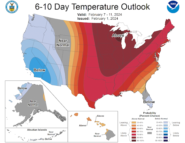
Perhaps this weather pattern will continue beyond the next week. The Climate Prediction Center predicts lower than normal temperatures with high probability for greater than normal precipitation for 07-11 February.

Satellite and Model Data: College of DuPage Weather Center
Quantitative Precipitation Forecasts: Weather Prediction Center QPF
6-10 Day Outlooks: Climate Prediction Center Temperature & Precipitation Outlooks


